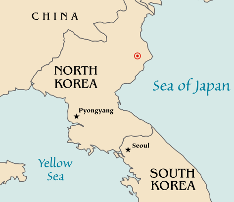
Fayl:2006 North Korean nuclear test.svg

Size of this PNG preview of this SVG file: 473 × 408 piksel. Boshqa oʻlchamlari: 278 × 240 piksel | 557 × 480 piksel | 890 × 768 piksel | 1 187 × 1 024 piksel | 2 374 × 2 048 piksel.
Asl fayl (SVG fayl, asl oʻlchamlari 473 × 408 piksel, fayl hajmi: 71 KB)
Fayl tarixi
Faylning biror paytdagi holatini koʻrish uchun tegishli sana/vaqtga bosingiz.
| Sana/Vaqt | Miniatura | Oʻlchamlari | Foydalanuvchi | Izoh | |
|---|---|---|---|---|---|
| joriy | 20:48, 2006-yil 10-oktyabr |  | 473 × 408 (71 KB) | Mobius | + Crop area, proper license |
| 20:43, 2006-yil 10-oktyabr |  | 981 × 801 (71 KB) | Mobius | Map of the North Korean nuclear test of October 9, 2006. The red marker indicates the estimated location of the test (41.311°N, 129.114°E). Based off of maps from the CIA World Factbook. |
Fayllarga ishoratlar
Bu faylga bogʻlangan sahifalar yoʻq.
Faylning global foydalanilishi
Ushbu fayl quyidagi vikilarda ishlatilyapti:
- ca.wikipedia.org loyihasida foydalanilishi
- en.wikipedia.org loyihasida foydalanilishi
- ia.wikipedia.org loyihasida foydalanilishi
- ko.wikipedia.org loyihasida foydalanilishi
- nl.wikipedia.org loyihasida foydalanilishi
- no.wikipedia.org loyihasida foydalanilishi
- pl.wikinews.org loyihasida foydalanilishi
- ta.wikinews.org loyihasida foydalanilishi
- www.wikidata.org loyihasida foydalanilishi


