Fayl:2011-P03-Drenthe-b54.jpg

Bu prevyuning hajmi: 519 × 599 piksel. Boshqa oʻlchamlari: 208 × 240 piksel | 416 × 480 piksel | 665 × 768 piksel | 1 072 × 1 238 piksel.
Asl fayl (1 072 × 1 238 piksel, fayl hajmi: 945 KB, MIME tipi: image/jpeg)
Qisqa izoh
| Taʼrif |
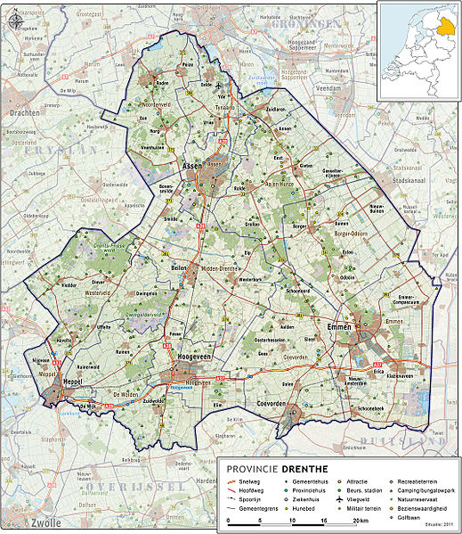
Nederlands: Provincie Drenthe, met indeling van gemeenten (2011) en impressie van het landschap.
Door Jan-Willem van Aalst, samengesteld uit publiek beschikbare geo-data:
|
| Sanasi | |
| Manba | Oʻzimning ishim |
| Muallif | Janwillemvanaalst |
| Other versions | 2009-Basisbeeld-Provincie03-Drenthe.jpg; 2010-P03-Drenthe-basisbeeld.jpg |
Litsenziyalash
I, the copyright holder of this work, hereby publish it under the following license:
Bu fayl Creative Commons asosida litsenziyalangan Attribution- Share Alike 3.0 Unported litsenziyasi.
- Siz erkinsiz:
- ulashishga – ishlanmani nusxalash, tarqatish va uzatish
- remiks qilishga – ishni moslashtirishga
- Quyidagi shartlar asosida:
- atribut – Siz tegishli litsenziyaga havolani taqdim etishingiz va oʻzgartirishlar kiritilganligini koʻrsatishingiz kerak. Siz buni har qanday oqilona yoʻl bilan qilishingiz mumkin, lekin litsenziar Sizni yoki Sizning foydalanishingizni ma'qullashini taklif qiladigan tarzda emas.
- bir xil ulashish – Agar Siz materialni remiks qilsangiz, oʻzgartirsangiz yoki unga asoslansangiz, oʻz hissalaringizni asl nusxadagi kabi bir xil yoki mos litsenziya ostida tarqatishingiz kerak.
Fayl tarixi
Faylning biror paytdagi holatini koʻrish uchun tegishli sana/vaqtga bosingiz.
| Sana/Vaqt | Miniatura | Oʻlchamlari | Foydalanuvchi | Izoh | |
|---|---|---|---|---|---|
| joriy | 05:53, 2011-yil 5-iyun | | 1 072 × 1 238 (945 KB) | Janwillemvanaalst | Added various village/town names |
| 06:51, 2011-yil 15-may |  | 1 070 × 1 235 (951 KB) | Janwillemvanaalst | Revision of sea and coastline; updated infrastructure (local roads) and points of interest (campings) | |
| 07:07, 2011-yil 24-aprel |  | 1 016 × 1 174 (869 KB) | Janwillemvanaalst | Updates of names, recreation locations, municipal borders in surrounding countries | |
| 16:53, 2011-yil 9-mart |  | 1 016 × 1 174 (850 KB) | Janwillemvanaalst | Added public health services; added regional road labels (N-roads) | |
| 19:01, 2011-yil 23-fevral |  | 1 016 × 1 174 (842 KB) | Janwillemvanaalst | Added cross-border features in Germany; Added local airports; Added Golf courses; Added major city parks. | |
| 08:40, 2011-yil 13-fevral |  | 1 016 × 1 174 (828 KB) | Janwillemvanaalst | Various map updates and some omissions corrected. Added various tourist locations. | |
| 11:08, 2010-yil 31-dekabr |  | 963 × 1 112 (706 KB) | Janwillemvanaalst | {{Information |Description={{nl|1=Provincie Drenthe, met indeling van gemeenten (2011) en impressie van het landschap. Door Jan-Willem van Aalst, samengesteld uit publiek beschikbare geo-data: * Referentie-ondergrond (kustlijn, steden, wegen) gerasterd ui |
Fayllarga ishoratlar
Bu faylga quyidagi sahifa bogʻlangan:
Faylning global foydalanilishi
Ushbu fayl quyidagi vikilarda ishlatilyapti: