Asl fayl (720 × 720 piksel, fayl hajmi: 3,16 MB, MIME tipi: image/gif, looped, 12 frames, 12 soniya)

Ushbu fayl Vikiomborga yuklangan boʻlib, boshqa loyihalarda ham qoʻllanilishi mumkin. Uning tavsif sahifasidan olingan maʼlumot quyida keltirilgan.

Qisqa izoh

Taʼrif
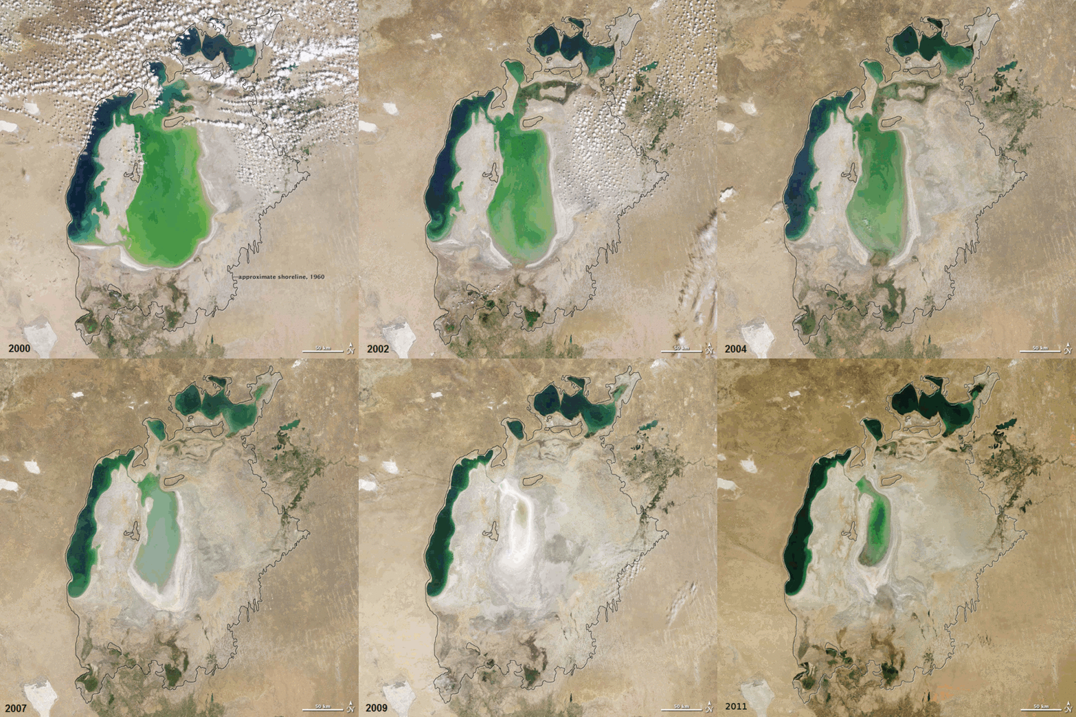
English: In the 1960s, the Soviet Union undertook a major water diversion project on the arid plains of Kazakhstan, Uzbekistan, and Turkmenistan. The region’s two major rivers, fed from snowmelt and precipitation in far-away mountains, were used to transform the desert into fields for cotton and other crops. Before the project, the two rivers left the mountains, cut northwest through the Kyzylkum Desert—the Syrdar’ya to the north and the Amudar’ya in parallel to the south—and finally pooled together in the lowest part of the desert basin. The lake they made, the Aral Sea, was once the fourth largest lake in the world.

Although irrigation made the desert bloom, it devastated the Aral Sea. This series of images from the Moderate Resolution Imaging Spectroradiometer (MODIS) on NASA’s Terra satellite documents the changes in the the Aral Sea throughout the past decade. At the start of the series in 2000, the lake was already a fraction of its 1960 extent (black line). The Northern Aral Sea (sometimes called the Small Aral Sea) had separated from the Southern (Large) Aral Sea. The Southern Aral Sea had split into an eastern and a western lobe that remained tenuously connected at both ends.

By 2001, the southern connection had been severed, and the shallower eastern part retreated rapidly over the next several years. Especially large retreats in the eastern lobe of the Southern Sea appear to have occurred between 2005 and 2006, and again between 2007 and 2008. The final image in the series is from the summer of 2009. Blowing dust (salt-laden sediments) covers a large part of the sea.

As the lake dried up, fisheries and the communities that depended on them collapsed. The increasingly salty water became polluted with fertilizer and pesticides. The blowing dust from the exposed lakebed, contaminated with agricultural chemicals, became a public health hazard. The salty dust blew off the lakebed and settled onto fields, degrading the soil. Croplands had to be flushed with larger and larger volumes of river water. The loss of the moderating influence of such a large body of water made winters colder and summers hotter and drier.

In a last-ditch effort to save some of the lake, Kazakhstan built a dam between the northern and southern parts of the Aral Sea. Completed in 2005, the dam was basically a death sentence for the southern Aral Sea, which was judged to be beyond saving. All of the water flowing into the desert basin from the Syrdar’ya now stays in the Northern Aral Sea. Between 2005 and 2006, the water levels in that part of the lake rebounded significantly and very small increases are visible throughout the rest of the time period. The differences in water color are due to changes in sediment.
 
This GIF graphic was created with GIMP.
Sanasi between 2000-now for the photos
Manba Evaporation of the Aral Sea
Muallif NASA Earth Observatory for the photos. ComputerHotline for the animation.
Thomas Bresson  
 
Thomas Bresson
Alternative names
Description French photographer
Date of birth 31 dekabr 1982
Location of birth Belfort
Work period from 2008
date QS:P,+2008-00-00T00:00:00Z/7,P580,+2008-00-00T00:00:00Z/9
; recognized photographer on Wikimedia Commons from 21 iyul 2009
date QS:P,+2009-07-21T00:00:00Z/7,P580,+2009-07-21T00:00:00Z/11
This photo / video was taken by Thomas Bresson.

Please credit this with : Photo : Thomas Bresson or Video : Thomas Bresson in the immediate vicinity of the image.

If you use one of my photos, please email me (account needed) or leave me a short message on my discussion page.
It would be greatly appreciated.
Do not copy this image illegally by ignoring the terms of the license below, as it is not in the public domain.

If you would like special permission to use, license, or purchase the image please contact me to negotiate terms.


العربية | বাংলা | English | français | македонски | Nederlands | Türkçe | +/−

Litsenziyalash

Public domain This file is in the public domain in the United States because it was solely created by NASA. NASA copyright policy states that "NASA material is not protected by copyright unless noted". (See Template:PD-USGov, NASA copyright policy page or JPL Image Use Policy.)
Warnings:

Captions

Add a one-line explanation of what this file represents

Items portrayed in this file

tasvirlangan obyekt

image/gif

checksum inglizcha

2912d7b11570f27abb8244fa3e774509570b3d9d

data size inglizcha

3 316 632 Bayt

12 soniya

width inglizcha

720 piksel

Fayl tarixi

Faylning biror paytdagi holatini koʻrish uchun tegishli sana/vaqtga bosingiz.

Sana/VaqtMiniaturaOʻlchamlariFoydalanuvchiIzoh
joriy07:38, 2011-yil 19-dekabr07:38, 2011-yil 19-dekabr dagi versiya uchun tasvir720 × 720 (3,16 MB)ComputerHotline== Summary == {{Information |Description={{en|In the 1960s, the Soviet Union undertook a major water diversion project on the arid plains of Kazakhstan, Uzbekistan, and Turkmenistan. The region’s two major rivers, fed from snowmelt and precipitation in
12:19, 2010-yil 25-dekabr12:19, 2010-yil 25-dekabr dagi versiya uchun tasvir720 × 720 (2,92 MB)ComputerHotline== Summary == {{Information |Description={{en|In the 1960s, the Soviet Union undertook a major water diversion project on the arid plains of Kazakhstan, Uzbekistan, and Turkmenistan. The region’s two major rivers, fed from snowmelt and precipitation in

Bu faylga quyidagi sahifa bogʻlangan:

Faylning global foydalanilishi

Ushbu fayl quyidagi vikilarda ishlatilyapti: