Asl fayl (1 200 × 1 184 piksel, fayl hajmi: 526 KB, MIME tipi: image/png)

Ushbu fayl Vikiomborga yuklangan boʻlib, boshqa loyihalarda ham qoʻllanilishi mumkin. Uning tavsif sahifasidan olingan maʼlumot quyida keltirilgan.

Qisqa izoh

Taʼrif
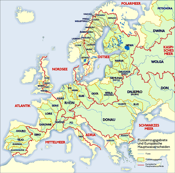
Deutsch: Grafik zeigt die Europäischen Flusseinzugsgebiete und Hauptwasserscheiden.

Zeichnung erstellt 06/2004 von Sansculotte. Bild ist unter der Creative Commons Share Alike zur weiteren Verwendung freigegeben.

Quellenangabe und Beleg an sansculotte@despammed.com erbeten.
English: The map shows the European rivers' catchment areas and main watersheds.

Chart made on 06/2004 by de:Sansculotte. The image is released under the Creative Commons Share Alike license for futher use.

Reference and sources can be requested from sansculotte@despammed.com
Français : Carte des bassins fluviaux d'Europe. Carte établie en juin 2004 par le contributeur de:Sansculotte

Sources (!) disponibles par demande à sansculotte@despammed.com

  • Fluß = River = Fleuve
  • Flußeinzugsgebiet = River drainage basin = Bassin fluvial
  • Europäische Hauptwassercheide = European main drainage divides (GB: watersheds)
Sanasi
Manba Source: German Wikipedia, original upload see file history
Muallif Sansculotte
Ruxsat
(Bu faylning takror foydalanilishi)
w:en:Creative Commons
atribut bir xil ulashish
This file is licensed under the Creative Commons Attribution-Share Alike 2.0 Generic license.
Siz erkinsiz:
  • ulashishga – ishlanmani nusxalash, tarqatish va uzatish
  • remiks qilishga – ishni moslashtirishga
Quyidagi shartlar asosida:
  • atribut – Siz tegishli litsenziyaga havolani taqdim etishingiz va oʻzgartirishlar kiritilganligini koʻrsatishingiz kerak. Siz buni har qanday oqilona yoʻl bilan qilishingiz mumkin, lekin litsenziar Sizni yoki Sizning foydalanishingizni ma'qullashini taklif qiladigan tarzda emas.
  • bir xil ulashish – Agar Siz materialni remiks qilsangiz, oʻzgartirsangiz yoki unga asoslansangiz, oʻz hissalaringizni asl nusxadagi kabi bir xil yoki mos litsenziya ostida tarqatishingiz kerak.
GNU head Ushbu hujjatdan nusxa ko‘chirish, tarqatish va/yoki o‘zgartirish uchun GNU Erkin guvohnoma litsenziyasi (GNU Free Documentation License), 1.2 va har qanday keyingi versiyalar shartlariga muvofiq ruxsat berilgan yoki Ochiq kodli dasturlar jamiyati (Free Software Foundation) tomonidan chop etilgan; oʻzgarmas boʻlimlarsiz, oldingi muqova matnlari va orqa muqova matnlarisiz. Litsenziya nusxasi GNU Erkin guvohnoma litsenziyasi (GNU Free Documentation License) boʻlimiga kiritilgan.
w:en:Creative Commons
atribut bir xil ulashish
Bu fayl Creative Commons asosida litsenziyalangan Attribution- Share Alike 3.0 Unported litsenziyasi.
Siz erkinsiz:
  • ulashishga – ishlanmani nusxalash, tarqatish va uzatish
  • remiks qilishga – ishni moslashtirishga
Quyidagi shartlar asosida:
  • atribut – Siz tegishli litsenziyaga havolani taqdim etishingiz va oʻzgartirishlar kiritilganligini koʻrsatishingiz kerak. Siz buni har qanday oqilona yoʻl bilan qilishingiz mumkin, lekin litsenziar Sizni yoki Sizning foydalanishingizni ma'qullashini taklif qiladigan tarzda emas.
  • bir xil ulashish – Agar Siz materialni remiks qilsangiz, oʻzgartirsangiz yoki unga asoslansangiz, oʻz hissalaringizni asl nusxadagi kabi bir xil yoki mos litsenziya ostida tarqatishingiz kerak.
This licensing tag was added to this file as part of the GFDL licensing update.
Other versions

Derivative works of this file:

This geology image could be re-created using vector graphics as an SVG file. This has several advantages; see Commons:Media for cleanup for more information. If an SVG form of this image is available, please upload it and afterwards replace this template with {{vector version available|new image name}}.


It is recommended to name the SVG file “Europäische Wasserscheiden.svg”—then the template Vector version available (or Vva) does not need the new image name parameter.

Vikipediya

 This is a featured picture on the German language Wikipedia (Exzellente Bilder) and is considered one of the finest images. See its nomination here.

If you think this file should be featured on Wikimedia Commons as well, feel free to nominate it.
If you have an image of similar quality that can be published under a suitable copyright license, be sure to upload it, tag it, and nominate it.

File history German Wikipedia

(Löschen) (Aktuell) 16:54, 15. Jan 2005 . . Sansculotte . . 1200x1184 (602233 Byte) (korr.)
(Löschen) (Zurücksetzen) 05:01, 3. Jun 2004 . . Sansculotte . . 1000x987 (262710 Byte) (eigene Darstellung, GNU FDL, Europäische Flußeinzugsgebiete und Hauptwasserscheiden)
(Löschen) (Zurücksetzen) 04:21, 3. Jun 2004 . . Sansculotte . . 1000x987 (183238 Byte) (eigene Darstellung, GNU FDL, Europäische Flußeinzugsgebiete und Hauptwasserscheiden)

Captions

Add a one-line explanation of what this file represents
The main rivers of Europe and their catchment areas.

Items portrayed in this file

tasvirlangan obyekt

3 iyun 2004

image/png

Fayl tarixi

Faylning biror paytdagi holatini koʻrish uchun tegishli sana/vaqtga bosingiz.

(eng yangi | eng eski) Koʻrib chiqish (yangiroq 10 | ) (10 | 20 | 50 | 100 | 250 | 500)
Sana/VaqtMiniaturaOʻlchamlariFoydalanuvchiIzoh
joriy08:45, 2019-yil 31-iyul08:45, 2019-yil 31-iyul dagi versiya uchun tasvir1 200 × 1 184 (526 KB)1970geminientschleiert
01:21, 2016-yil 16-may01:21, 2016-yil 16-may dagi versiya uchun tasvir1 200 × 1 184 (279 KB)Ulamm- Klare Farben für klar eInformationen - Ladogasee und finnische Flüsse nachgetragen - Wasser aus den Kattegat-Zuflüssen fließt nicht in die Ostsee; Zuordnung des Kattegat zur Ostsee nautisch und mangels eigener Meereseinheit
22:03, 2016-yil 16-yanvar22:03, 2016-yil 16-yanvar dagi versiya uchun tasvir1 200 × 1 184 (766 KB)Francis McLloydGrenzen in Südschweden, im Osten von Dänemark und westliche Ostsee ergänzt (jetzt)
21:59, 2016-yil 16-yanvar21:59, 2016-yil 16-yanvar dagi versiya uchun tasvir1 200 × 1 184 (763 KB)Francis McLloydGrenzen in Südschweden, im Osten von Dänemark und westliche Ostsee ergänzt
20:21, 2016-yil 16-yanvar20:21, 2016-yil 16-yanvar dagi versiya uchun tasvir1 200 × 1 184 (760 KB)Francis McLloydGrenze im Nord-Osten zwischen Newa und Kemijoki verbessert. Gebiete westlich des Newas hinzugefügt.
19:12, 2011-yil 11-mart19:12, 2011-yil 11-mart dagi versiya uchun tasvir1 200 × 1 184 (723 KB)W like wikia small part of the Adria-Mittelmeer drainage was missing. But i don t have time to check exactly, thats why only doted line.
18:14, 2011-yil 11-mart18:14, 2011-yil 11-mart dagi versiya uchun tasvir1 200 × 1 184 (724 KB)W like wikiDrainage divide in Italy, Denmark, UK and Gibraltar corrected. By the way: If someone have time and a better map than me, the doted line in Finnland should be replaced by "full line".
13:59, 2011-yil 7-yanvar13:59, 2011-yil 7-yanvar dagi versiya uchun tasvir1 200 × 1 184 (849 KB)CareSaimaa fix
14:44, 2010-yil 24-fevral14:44, 2010-yil 24-fevral dagi versiya uchun tasvir1 200 × 1 184 (564 KB)DcoetzeeRemove watermark, pngcrush
19:26, 2009-yil 2-iyul19:26, 2009-yil 2-iyul dagi versiya uchun tasvir1 200 × 1 184 (552 KB)NordNordWestDanube corrected, plus names of Vardar and Mariza
(eng yangi | eng eski) Koʻrib chiqish (yangiroq 10 | ) (10 | 20 | 50 | 100 | 250 | 500)

Bu faylga quyidagi sahifa bogʻlangan:

Faylning global foydalanilishi

Ushbu fayl quyidagi vikilarda ishlatilyapti:

Ushbu faylni koʻproq global foydalanishdan koʻring.