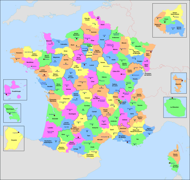
Fayl:France départementale.svg

Size of this PNG preview of this SVG file: 632 × 600 piksel. Boshqa oʻlchamlari: 253 × 240 piksel | 506 × 480 piksel | 809 × 768 piksel | 1 079 × 1 024 piksel | 2 158 × 2 048 piksel | 2 000 × 1 898 piksel.
Asl fayl (SVG fayl, asl oʻlchamlari 2 000 × 1 898 piksel, fayl hajmi: 1,87 MB)
Fayl tarixi
Faylning biror paytdagi holatini koʻrish uchun tegishli sana/vaqtga bosingiz.
| Sana/Vaqt | Miniatura | Oʻlchamlari | Foydalanuvchi | Izoh | |
|---|---|---|---|---|---|
| joriy | 20:29, 2022-yil 22-iyun |  | 2 000 × 1 898 (1,87 MB) | OpesMentis | Added hyphens on departments' names and towns' names and fixed "Réunion" to "La Réunion" |
| 18:10, 2021-yil 9-noyabr |  | 2 000 × 1 898 (1,87 MB) | Puck04 | fixed SVG code (was "W3C-invalid") + cleanup using text editor; contains some invisible pathes | |
| 00:40, 2020-yil 1-may |  | 2 000 × 1 898 (4,7 MB) | ChrisPtDe | File uploaded using svgtranslate tool (https://tools.wmflabs.org/svgtranslate/). Added translation for frp. | |
| 22:17, 2020-yil 28-aprel |  | 2 000 × 1 898 (4,7 MB) | ChrisPtDe | File uploaded using svgtranslate tool (https://tools.wmflabs.org/svgtranslate/). Added translation for frp. | |
| 22:56, 2020-yil 25-aprel |  | 2 000 × 1 898 (4,68 MB) | ChrisPtDe | File uploaded using svgtranslate tool (https://tools.wmflabs.org/svgtranslate/). Added translation for frp. | |
| 14:13, 2018-yil 4-noyabr |  | 2 000 × 1 898 (4,55 MB) | Nilstilar | Corse "réunifiée" pose problème | |
| 12:05, 2018-yil 4-noyabr |  | 2 000 × 1 898 (4,54 MB) | Nilstilar | Corse "réunifiée" (collectivité territoriale unique — département & région — au 1/1/2018) | |
| 13:01, 2018-yil 15-oktyabr |  | 2 000 × 1 898 (4,55 MB) | Nilstilar | Reverted to version as of 18:52, 10 May 2017 (UTC) | |
| 22:30, 2017-yil 28-dekabr |  | 2 000 × 1 898 (2,24 MB) | Ras67 | frame removed, all invisible data stripped | |
| 18:52, 2017-yil 10-may |  | 2 000 × 1 898 (4,55 MB) | Nilstilar | Rétablissement des limites régionales (au 01/10/2016) |
Fayllarga ishoratlar
Bu faylga quyidagi sahifa bogʻlangan:
Faylning global foydalanilishi
Ushbu fayl quyidagi vikilarda ishlatilyapti:
- ar.wikipedia.org loyihasida foydalanilishi
- arz.wikipedia.org loyihasida foydalanilishi
- ast.wikipedia.org loyihasida foydalanilishi
- ast.wiktionary.org loyihasida foydalanilishi
- az.wikipedia.org loyihasida foydalanilishi
- bg.wikipedia.org loyihasida foydalanilishi
- br.wikipedia.org loyihasida foydalanilishi
- ca.wikipedia.org loyihasida foydalanilishi
- cy.wikipedia.org loyihasida foydalanilishi
- el.wikipedia.org loyihasida foydalanilishi
- en.wikipedia.org loyihasida foydalanilishi
- es.wikipedia.org loyihasida foydalanilishi
- eu.wikipedia.org loyihasida foydalanilishi
- fr.wikipedia.org loyihasida foydalanilishi
- Département français
- Monument historique (France)
- Géographie de la Guadeloupe
- Économie de la Guadeloupe
- Transports en France
- Liste des ponts de Paris
- Géographie de la Drôme
- Liste des anciennes communes du Loiret
- Économie de La Réunion
- Politique dans la Haute-Vienne
- Politique dans la Creuse
- Climat des Yvelines
- Géographie du Territoire de Belfort
- Culture en Guyane
- Économie du Puy-de-Dôme
- Géographie de la Charente-Maritime
- Économie de l'Oise
- Économie de la Haute-Savoie
- Climat de l'Aveyron
- Climat du Bas-Rhin
- Climat du Haut-Rhin
- Géographie du Loiret
- Arboretum de Balaine
- Transports dans la métropole de Lyon
- Économie de la Haute-Saône
- Climat du Finistère
- Politique à La Réunion
- Géographie d'Eure-et-Loir
- Transport en Corse
- Liste des musées de Paris
Ushbu faylni koʻproq global foydalanishdan koʻring.


