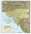
Fayl:Guinea Bissau Map.jpg

Bu prevyuning hajmi: 557 × 600 piksel. Boshqa oʻlchamlari: 223 × 240 piksel | 446 × 480 piksel | 713 × 768 piksel | 1 040 × 1 120 piksel.
Asl fayl (1 040 × 1 120 piksel, fayl hajmi: 228 KB, MIME tipi: image/jpeg)
Fayl tarixi
Faylning biror paytdagi holatini koʻrish uchun tegishli sana/vaqtga bosingiz.
| Sana/Vaqt | Miniatura | Oʻlchamlari | Foydalanuvchi | Izoh | |
|---|---|---|---|---|---|
| joriy | 13:14, 2006-yil 22-fevral |  | 1 040 × 1 120 (228 KB) | Lupo | Shaded relief map of Guinea-Bissau. Source: [http://www.lib.utexas.edu/maps/africa/guinea_bissau_rel93.jpg] from the [http://www.lib.utexas.edu/maps/africa.html Perry-Castañeda Library Map Collection]. {{PD-USGov-CIA}} [[Category:Maps of Guinea Bi |
Fayllarga ishoratlar
Bu faylga quyidagi sahifa bogʻlangan:
Faylning global foydalanilishi
Ushbu fayl quyidagi vikilarda ishlatilyapti:
- ca.wikipedia.org loyihasida foydalanilishi
- en.wikipedia.org loyihasida foydalanilishi
- es.wikipedia.org loyihasida foydalanilishi
- fa.wikipedia.org loyihasida foydalanilishi
- ha.wikipedia.org loyihasida foydalanilishi
- hr.wiktionary.org loyihasida foydalanilishi
- it.wikipedia.org loyihasida foydalanilishi
- ja.wikipedia.org loyihasida foydalanilishi
- lt.wikipedia.org loyihasida foydalanilishi
- nl.wikipedia.org loyihasida foydalanilishi
- no.wikipedia.org loyihasida foydalanilishi
- pl.wikipedia.org loyihasida foydalanilishi
- pt.wikipedia.org loyihasida foydalanilishi
- ru.wiktionary.org loyihasida foydalanilishi
- sa.wikipedia.org loyihasida foydalanilishi
- uk.wikipedia.org loyihasida foydalanilishi
- vec.wikipedia.org loyihasida foydalanilishi
