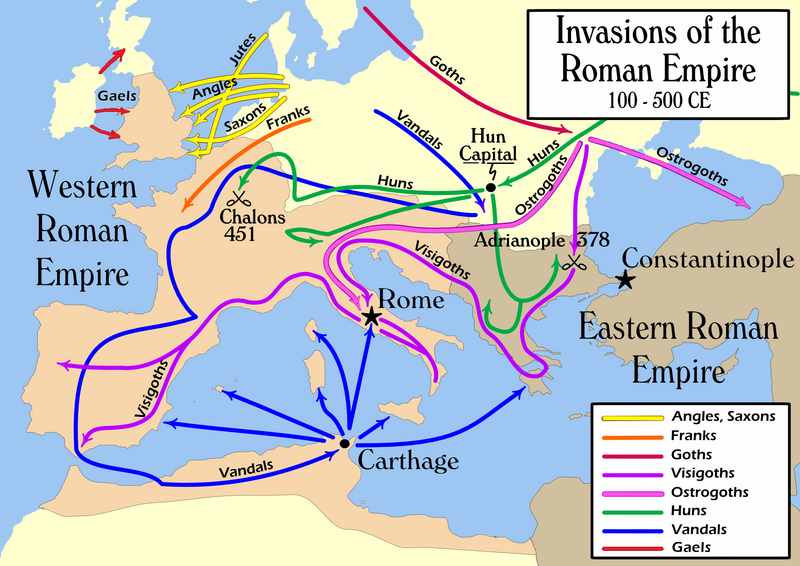
Fayl:Invasions of the Roman Empire 1.png

Bu prevyuning hajmi: 800 × 566 piksel. Boshqa oʻlchamlari: 320 × 226 piksel | 640 × 453 piksel | 1 024 × 724 piksel | 1 280 × 905 piksel | 1 954 × 1 382 piksel.
Asl fayl (1 954 × 1 382 piksel, fayl hajmi: 269 KB, MIME tipi: image/png)
Fayl tarixi
Faylning biror paytdagi holatini koʻrish uchun tegishli sana/vaqtga bosingiz.
| Sana/Vaqt | Miniatura | Oʻlchamlari | Foydalanuvchi | Izoh | |
|---|---|---|---|---|---|
| joriy | 21:08, 2022-yil 14-fevral |  | 1 954 × 1 382 (269 KB) | SKIBLY101 | add the scotti |
| 03:36, 2022-yil 9-yanvar |  | 1 954 × 1 362 (127 KB) | Jul059 | Lossless file size reduction | |
| 16:07, 2014-yil 26-fevral |  | 1 954 × 1 362 (139 KB) | Capmo | cropped very minor white margin | |
| 08:35, 2007-yil 17-iyul |  | 1 962 × 1 374 (139 KB) | Nihad Hamzic | Removed alpha channel, what enabled me to losslessly reduce color domain to 8-bit. The result is a much, much smaller file. If alpha channel is indeed needed, then just revert the actual image to the one which I had previously uploaded (around 480 KB). | |
| 10:48, 2007-yil 16-iyul |  | 1 962 × 1 374 (488 KB) | Nihad Hamzic | Further reduced image size by losslessly optimising PNG compression type. This image's color domain could be reduced to 8-bit if alpha channel was removed, resulting in enormous image size reducion. Is alpha channel really needed here? | |
| 19:27, 2006-yil 31-oktyabr |  | 1 962 × 1 374 (624 KB) | MapMaster | Smaller, with some corrections and improvements | |
| 15:17, 2006-yil 21-oktyabr |  | 1 959 × 1 398 (603 KB) | MapMaster | Improved version | |
| 21:35, 2006-yil 19-oktyabr |  | 1 961 × 1 405 (602 KB) | MapMaster | I corrected the "Huns" route on this map, and am attempting to uploaded a 50% smaller version (Kbyte-wise). | |
| 01:35, 2006-yil 2-oktyabr |  | 3 948 × 2 827 (1,28 MB) | MapMaster | uploaded improved map | |
| 18:27, 2006-yil 1-oktyabr |  | 3 944 × 2 814 (1,04 MB) | MapMaster | Map of the "barbarian" invasions of the Roman Empire |
Fayllarga ishoratlar
Bu faylga quyidagi sahifa bogʻlangan:
Faylning global foydalanilishi
Ushbu fayl quyidagi vikilarda ishlatilyapti:
- af.wikipedia.org loyihasida foydalanilishi
- ar.wikipedia.org loyihasida foydalanilishi
- azb.wikipedia.org loyihasida foydalanilishi
- az.wikipedia.org loyihasida foydalanilishi
- ba.wikipedia.org loyihasida foydalanilishi
- be-tarask.wikipedia.org loyihasida foydalanilishi
- be.wikipedia.org loyihasida foydalanilishi
- bg.wikipedia.org loyihasida foydalanilishi
- ckb.wikipedia.org loyihasida foydalanilishi
- csb.wikipedia.org loyihasida foydalanilishi
- cs.wikipedia.org loyihasida foydalanilishi
- da.wikipedia.org loyihasida foydalanilishi
- de.wikipedia.org loyihasida foydalanilishi
- de.wikibooks.org loyihasida foydalanilishi
- diq.wikipedia.org loyihasida foydalanilishi
- el.wikipedia.org loyihasida foydalanilishi
- en.wikipedia.org loyihasida foydalanilishi
Ushbu faylni koʻproq global foydalanishdan koʻring.


