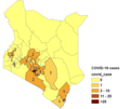
Fayl:Kenya corona county map 26032020.png

Bu prevyuning hajmi: 800 × 587 piksel. Boshqa oʻlchamlari: 320 × 235 piksel | 640 × 469 piksel | 979 × 718 piksel.
Asl fayl (979 × 718 piksel, fayl hajmi: 71 KB, MIME tipi: image/png)
Fayl tarixi
Faylning biror paytdagi holatini koʻrish uchun tegishli sana/vaqtga bosingiz.
| Sana/Vaqt | Miniatura | Oʻlchamlari | Foydalanuvchi | Izoh | |
|---|---|---|---|---|---|
| joriy | 15:54, 2020-yil 3-aprel |  | 979 × 718 (71 KB) | Gozar | made wider for visibility again |
| 15:52, 2020-yil 3-aprel |  | 854 × 719 (70 KB) | Gozar | widened image to increase visibility | |
| 15:42, 2020-yil 3-aprel |  | 523 × 702 (57 KB) | Gozar | added number labels for counties to map | |
| 15:26, 2020-yil 3-aprel |  | 496 × 671 (23 KB) | Gozar | updated to reflect distribution by county as of 3 April, 2020 | |
| 14:56, 2020-yil 2-aprel |  | 499 × 665 (22 KB) | Gozar | increased font size of legend to improve visibility | |
| 14:52, 2020-yil 2-aprel |  | 495 × 631 (21 KB) | Gozar | updated to have shaded map with number of cases per county with legend as of March 30 | |
| 21:37, 2020-yil 1-aprel |  | 527 × 663 (20 KB) | Gozar | updated to April 1 | |
| 15:02, 2020-yil 26-mart |  | 439 × 574 (36 KB) | Gozar | Uploaded own work with UploadWizard |
Fayllarga ishoratlar
Bu faylga quyidagi sahifa bogʻlangan:
Faylning global foydalanilishi
Ushbu fayl quyidagi vikilarda ishlatilyapti:
- ar.wikipedia.org loyihasida foydalanilishi
- ca.wikipedia.org loyihasida foydalanilishi
- fr.wikipedia.org loyihasida foydalanilishi
- it.wikipedia.org loyihasida foydalanilishi
- pl.wikipedia.org loyihasida foydalanilishi
- tr.wikipedia.org loyihasida foydalanilishi