Khazarfall1.png (670 × 448 piksel, fayl hajmi: 32 KB, MIME tipi: image/png)

Ushbu fayl Vikiomborga yuklangan boʻlib, boshqa loyihalarda ham qoʻllanilishi mumkin. Uning tavsif sahifasidan olingan maʼlumot quyida keltirilgan.

By the year of 996 Poland extended to Oder river in the north-west and well in to Bautzen (Budziszyn) in the south also included Silesia (Slask)and part of Moravia. It is observed that Gernman Wikipedia "watchers" constantly place their borders way east as to create false claims to the historic lechitic territory as their own. Please correct this falsely created map to the correct shape.

Qisqa izoh

Taʼrif
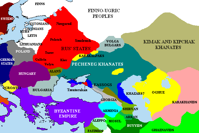
English: The Pontic steppes, c. 1015 (areas in blue possibly still under Khazar control).
Sanasi
Manba Unknown (http://en.wikipedia.org/wiki/Image:Khazarfall1.png)
Muallif Unknown authorUnknown author
File:Khazarfall1.svg is a vector version of this file. It should be used in place of this PNG file when not inferior.

File:Khazarfall1.png → File:Khazarfall1.svg

For more information, see Help:SVG.

In other languages
Alemannisch  Bahasa Indonesia  Bahasa Melayu  British English  català  čeština  dansk  Deutsch  eesti  English  español  Esperanto  euskara  français  Frysk  galego  hrvatski  Ido  italiano  lietuvių  magyar  Nederlands  norsk bokmål  norsk nynorsk  occitan  Plattdüütsch  polski  português  português do Brasil  română  Scots  sicilianu  slovenčina  slovenščina  suomi  svenska  Tiếng Việt  Türkçe  vèneto  Ελληνικά  беларуская (тарашкевіца)  български  македонски  нохчийн  русский  српски / srpski  татарча/tatarça  українська  ქართული  հայերեն  বাংলা  தமிழ்  മലയാളം  ไทย  한국어  日本語  简体中文  繁體中文  עברית  العربية  فارسی  +/−
New SVG image

Litsenziyalash

Note: "subject to disclaimers" below may not actually apply. This file was tagged with {{GFDL-user-en}}, and after May 2007, Template:GFDL-self (on English Wikipedia) did not require disclaimers. Please check the image description page on the English Wikipedia (or, if it has been deleted, ask an English Wikipedia administrator). See Wikipedia:GFDL standardization for details.

Exact dates for disclaimers to apply
Anything uploaded on the English Wikipedia with Template:GFDL-self within the following dates has disclaimers applicable. Otherwise, no disclaimers are applicable.
  • 22:43, 20 February 2004 to 17:19, 25 November 2005
  • 23:00, 26 November 2005 to 23:28, 18 May 2007
  • 21:17, 19 May 2007 to 20:01, 21 May 2007
For Template:GFDL, the dates are slightly different:
  • 21:43, 20 February 2004 to 16:27, 10 May 2007
Briangotts from en.wikipedia.org, the copyright holder of this work, hereby publishes it under the following license:
GNU head Ushbu hujjatdan nusxa ko‘chirish, tarqatish va/yoki o‘zgartirish uchun GNU Erkin guvohnoma litsenziyasi (GNU Free Documentation License), 1.2 va har qanday keyingi versiyalar shartlariga muvofiq ruxsat berilgan yoki Ochiq kodli dasturlar jamiyati (Free Software Foundation) tomonidan chop etilgan; oʻzgarmas boʻlimlarsiz, oldingi muqova matnlari va orqa muqova matnlarisiz. Litsenziya nusxasi GNU Erkin guvohnoma litsenziyasi (GNU Free Documentation License) boʻlimiga kiritilgan.
w:en:Creative Commons
atribut bir xil ulashish
Bu fayl Creative Commons asosida litsenziyalangan Attribution- Share Alike 3.0 Unported litsenziyasi.
Attributsiya: Briangotts
Siz erkinsiz:
  • ulashishga – ishlanmani nusxalash, tarqatish va uzatish
  • remiks qilishga – ishni moslashtirishga
Quyidagi shartlar asosida:
  • atribut – Siz tegishli litsenziyaga havolani taqdim etishingiz va oʻzgartirishlar kiritilganligini koʻrsatishingiz kerak. Siz buni har qanday oqilona yoʻl bilan qilishingiz mumkin, lekin litsenziar Sizni yoki Sizning foydalanishingizni ma'qullashini taklif qiladigan tarzda emas.
  • bir xil ulashish – Agar Siz materialni remiks qilsangiz, oʻzgartirsangiz yoki unga asoslansangiz, oʻz hissalaringizni asl nusxadagi kabi bir xil yoki mos litsenziya ostida tarqatishingiz kerak.
This licensing tag was added to this file as part of the GFDL licensing update.

Note: This tag should not be used. For images that were released on the English Wikipedia using either GFDL or GFDL-self with disclaimers, use {{GFDL-user-en-with-disclaimers}}. For images without disclaimers please use {{GFDL-user-en-no-disclaimers}} instead. If you are the copyright holder of files that were released on Wikipedia, please consider removing the disclaimers.

Captions

Add a one-line explanation of what this file represents

Items portrayed in this file

tasvirlangan obyekt

image/png

20 aprel 2006

Fayl tarixi

Faylning biror paytdagi holatini koʻrish uchun tegishli sana/vaqtga bosingiz.

(eng yangi | eng eski) Koʻrib chiqish (yangiroq 10 | ) (10 | 20 | 50 | 100 | 250 | 500)
Sana/VaqtMiniaturaOʻlchamlariFoydalanuvchiIzoh
joriy00:15, 2023-yil 30-aprel00:15, 2023-yil 30-aprel dagi versiya uchun tasvir670 × 448 (32 KB)Андрей Романенкоcorrected (Rostov had been misplaced)
19:51, 2021-yil 24-yanvar19:51, 2021-yil 24-yanvar dagi versiya uchun tasvir670 × 448 (36 KB)Taron SaharyanReverted to version as of 15:10, 27 May 2018 (UTC)
02:04, 2019-yil 2-sentyabr02:04, 2019-yil 2-sentyabr dagi versiya uchun tasvir670 × 448 (33 KB)GeorgianoReverted to version as of 12:54, 22 March 2017 (UTC)
15:10, 2018-yil 27-may15:10, 2018-yil 27-may dagi versiya uchun tasvir670 × 448 (36 KB)Taron Saharyanвсе армянские города, в том числе столица Ани, оказались в Грузии
12:54, 2017-yil 22-mart12:54, 2017-yil 22-mart dagi versiya uchun tasvir670 × 448 (33 KB)GeorgianoReverted to version as of 08:28, 2 December 2015 (UTC)
21:25, 2017-yil 6-yanvar21:25, 2017-yil 6-yanvar dagi versiya uchun tasvir670 × 448 (36 KB)Calrugemfixed caucasus
08:28, 2015-yil 2-dekabr08:28, 2015-yil 2-dekabr dagi versiya uchun tasvir670 × 448 (33 KB)Taron SaharyanReverted to version as of 10:12, 1 November 2015 (UTC)
08:23, 2015-yil 2-dekabr08:23, 2015-yil 2-dekabr dagi versiya uchun tasvir670 × 448 (44 KB)Taron Saharyanкоррекция границ Армении при Гагике I
10:12, 2015-yil 1-noyabr10:12, 2015-yil 1-noyabr dagi versiya uchun tasvir670 × 448 (33 KB)Skylight 555.
10:02, 2015-yil 1-noyabr10:02, 2015-yil 1-noyabr dagi versiya uchun tasvir1 000 × 671 (294 KB)Skylight 555Карта территории Печенегов и прилегающих государств.
(eng yangi | eng eski) Koʻrib chiqish (yangiroq 10 | ) (10 | 20 | 50 | 100 | 250 | 500)

Bu faylga quyidagi sahifa bogʻlangan:

Faylning global foydalanilishi

Ushbu fayl quyidagi vikilarda ishlatilyapti:

Ushbu faylni koʻproq global foydalanishdan koʻring.
Metama’lumot