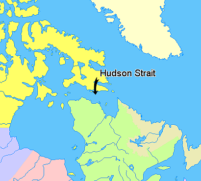
Fayl:Map indicating Hudson Strait, Nunavut, Canada.png
Map_indicating_Hudson_Strait,_Nunavut,_Canada.png (410 × 370 piksel, fayl hajmi: 52 KB, MIME tipi: image/png)
Fayl tarixi
Faylning biror paytdagi holatini koʻrish uchun tegishli sana/vaqtga bosingiz.
| Sana/Vaqt | Miniatura | Oʻlchamlari | Foydalanuvchi | Izoh | |
|---|---|---|---|---|---|
| joriy | 13:55, 2006-yil 21-mart |  | 410 × 370 (52 KB) | David Kernow~commonswiki | == Summary == Map indicating Hudson Strait, Nunavut, Canada. {{legend|#ffff66|Nunavut}} {{legend|#ffffcc|Greenland}} {{legend|#d5fe94|Quebec}} {{legend|#ecebb6|Newfoundland and Labrador}} {{legend|#ccccff|Manitoba}} {{legend|#ffcccc|O |
Fayllarga ishoratlar
Bu faylga quyidagi 2 sahifalar bogʻlangan:
Faylning global foydalanilishi
Ushbu fayl quyidagi vikilarda ishlatilyapti:
- ar.wikipedia.org loyihasida foydalanilishi
- az.wikipedia.org loyihasida foydalanilishi
- ba.wikipedia.org loyihasida foydalanilishi
- bg.wikipedia.org loyihasida foydalanilishi
- bn.wikipedia.org loyihasida foydalanilishi
- ca.wikipedia.org loyihasida foydalanilishi
- cs.wikipedia.org loyihasida foydalanilishi
- da.wikipedia.org loyihasida foydalanilishi
- de.wikipedia.org loyihasida foydalanilishi
- en.wikipedia.org loyihasida foydalanilishi
- eo.wikipedia.org loyihasida foydalanilishi
- eu.wikipedia.org loyihasida foydalanilishi
- fa.wikipedia.org loyihasida foydalanilishi
- fi.wikipedia.org loyihasida foydalanilishi
- fr.wikipedia.org loyihasida foydalanilishi
- he.wikipedia.org loyihasida foydalanilishi
- hr.wikipedia.org loyihasida foydalanilishi
- id.wikipedia.org loyihasida foydalanilishi
- it.wikipedia.org loyihasida foydalanilishi
- ka.wikipedia.org loyihasida foydalanilishi
- la.wikipedia.org loyihasida foydalanilishi
- li.wikipedia.org loyihasida foydalanilishi
- lt.wikipedia.org loyihasida foydalanilishi
- mhr.wikipedia.org loyihasida foydalanilishi
- ml.wikipedia.org loyihasida foydalanilishi
- nl.wikipedia.org loyihasida foydalanilishi
- nn.wikipedia.org loyihasida foydalanilishi
- no.wikipedia.org loyihasida foydalanilishi
- pl.wikipedia.org loyihasida foydalanilishi
- pt.wikipedia.org loyihasida foydalanilishi
- ru.wikipedia.org loyihasida foydalanilishi
- simple.wikipedia.org loyihasida foydalanilishi
- sk.wikipedia.org loyihasida foydalanilishi
- sl.wikipedia.org loyihasida foydalanilishi
- sr.wikipedia.org loyihasida foydalanilishi
- sv.wikipedia.org loyihasida foydalanilishi
- sw.wikipedia.org loyihasida foydalanilishi
- vi.wikipedia.org loyihasida foydalanilishi
- war.wikipedia.org loyihasida foydalanilishi

