Fayl:Oregoncountry.png

Bu prevyuning hajmi: 588 × 599 piksel. Boshqa oʻlchamlari: 236 × 240 piksel | 471 × 480 piksel | 1 000 × 1 019 piksel.
Asl fayl (1 000 × 1 019 piksel, fayl hajmi: 1,25 MB, MIME tipi: image/png)
Fayl tarixi
Faylning biror paytdagi holatini koʻrish uchun tegishli sana/vaqtga bosingiz.
| Sana/Vaqt | Miniatura | Oʻlchamlari | Foydalanuvchi | Izoh | |
|---|---|---|---|---|---|
| joriy | 18:36, 2008-yil 28-avgust |  | 1 000 × 1 019 (1,25 MB) | Kmusser | Added York Factory Express and increased resolution |
| 12:41, 2006-yil 10-aprel |  | 593 × 600 (139 KB) | Kmusser | ||
| 17:58, 2006-yil 6-aprel |  | 593 × 600 (139 KB) | Kmusser | ||
| 16:52, 2006-yil 6-aprel |  | 593 × 600 (135 KB) | Kmusser | ||
| 18:27, 2006-yil 5-aprel |  | 593 × 600 (135 KB) | Kmusser | ||
| 16:53, 2006-yil 5-aprel |  | 593 × 600 (135 KB) | Kmusser | ||
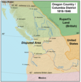
| 16:24, 2006-yil 5-aprel |  | 593 × 600 (135 KB) | Kmusser | This map shows Oregon Country and the border dispute between the U.S. and Britain, 1818-1846. |
Fayllarga ishoratlar
Bu faylga quyidagi sahifa bogʻlangan:
Faylning global foydalanilishi
Ushbu fayl quyidagi vikilarda ishlatilyapti:
- ar.wikipedia.org loyihasida foydalanilishi
- ca.wikipedia.org loyihasida foydalanilishi
- cy.wikipedia.org loyihasida foydalanilishi
- de.wikipedia.org loyihasida foydalanilishi
- en.wikipedia.org loyihasida foydalanilishi
- Oregon Trail
- Oregon Treaty
- Oregon boundary dispute
- Canada–United States border
- Sterling Price
- United Kingdom–United States relations
- User:Kmusser/Images
- History of Oregon
- Portal:Oregon
- User:EncMstr/sandbox
- Wikipedia:Graphics Lab/Map workshop/Archive/Nov 2014
- User:Falcaorib/Canada, United States and Mexico
- eo.wikipedia.org loyihasida foydalanilishi
- es.wikipedia.org loyihasida foydalanilishi
- fi.wikipedia.org loyihasida foydalanilishi
- he.wikipedia.org loyihasida foydalanilishi
- hi.wikipedia.org loyihasida foydalanilishi
- hy.wikipedia.org loyihasida foydalanilishi
- id.wikipedia.org loyihasida foydalanilishi
- io.wikipedia.org loyihasida foydalanilishi
- it.wikipedia.org loyihasida foydalanilishi
- ja.wikipedia.org loyihasida foydalanilishi
- ka.wikipedia.org loyihasida foydalanilishi
- ko.wikipedia.org loyihasida foydalanilishi
- lt.wikipedia.org loyihasida foydalanilishi
- lv.wikipedia.org loyihasida foydalanilishi
Ushbu faylni koʻproq global foydalanishdan koʻring.
