Fayl:Livingston-Island-Map-2010.jpg

Bu prevyuning hajmi: 800 × 555 piksel. Boshqa oʻlchamlari: 320 × 222 piksel | 640 × 444 piksel | 1 024 × 710 piksel | 1 280 × 888 piksel | 2 560 × 1 776 piksel | 5 027 × 3 487 piksel.
Asl fayl (5 027 × 3 487 piksel, fayl hajmi: 7,07 MB, MIME tipi: image/jpeg)
Qisqa izoh
| Taʼrif |
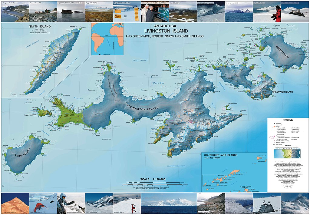
English: L.L. Ivanov. Antarctica: Livingston Island and Greenwich, Robert, Snow and Smith Islands. Scale 1:120000 topographic map. Troyan: Manfred Wörner Foundation, 2010. ISBN 978-954-92032-9-5 (First edition 2009. ISBN 978-954-92032-6-4) |
| Sanasi | |
| Manba | Oʻzimning ishim |
| Muallif | Apcbg |
| Ruxsat (Bu faylning takror foydalanilishi) |
Litsenziyalash
I, the copyright holder of this work, hereby publish it under the following license:
This file is licensed under the Creative Commons Attribution-Share Alike 4.0 International license.
- Siz erkinsiz:
- ulashishga – ishlanmani nusxalash, tarqatish va uzatish
- remiks qilishga – ishni moslashtirishga
- Quyidagi shartlar asosida:
- atribut – Siz tegishli litsenziyaga havolani taqdim etishingiz va oʻzgartirishlar kiritilganligini koʻrsatishingiz kerak. Siz buni har qanday oqilona yoʻl bilan qilishingiz mumkin, lekin litsenziar Sizni yoki Sizning foydalanishingizni ma'qullashini taklif qiladigan tarzda emas.
- bir xil ulashish – Agar Siz materialni remiks qilsangiz, oʻzgartirsangiz yoki unga asoslansangiz, oʻz hissalaringizni asl nusxadagi kabi bir xil yoki mos litsenziya ostida tarqatishingiz kerak.
Published by the Manfred Wörner Foundation, and hereby released by the Foundation’s President and CEO Apcbg (Lyubomir Ivanov) for publication under the Creative Commons Attribution ShareAlike 4.0 license.
Fayl tarixi
Faylning biror paytdagi holatini koʻrish uchun tegishli sana/vaqtga bosingiz.
| Sana/Vaqt | Miniatura | Oʻlchamlari | Foydalanuvchi | Izoh | |
|---|---|---|---|---|---|
| joriy | 04:46, 2015-yil 29-iyun | | 5 027 × 3 487 (7,07 MB) | Apcbg | {{Information |Description ={{en|1= L.L. Ivanov. Antarctica: Livingston Island and Greenwich, Robert, Snow and Smith Islands. Scale 1:120000 topographic map. Troyan: Manfred Wörner Foundation, 2010. ISBN 978-954-92032-9-5 (First edition 2009. ISBN... |
Fayllarga ishoratlar
Bu faylga quyidagi 2 sahifalar bogʻlangan:
Faylning global foydalanilishi
Ushbu fayl quyidagi vikilarda ishlatilyapti:
- af.wikipedia.org loyihasida foydalanilishi
- ast.wikipedia.org loyihasida foydalanilishi
- az.wikipedia.org loyihasida foydalanilishi
- Cənubi Şetland adaları
- Mikalvi buxtası
- Kruni buxtası
- Zahari burnu
- Neqra burnu
- Edvards burnu
- Robert burnu
- Tsepina buxtası
- Somovit burnu
- Batuliya burnu
- Sadala burnu
- Kitçen burnu
- Smirnenski burnu
- Qarinya buxtası
- Qrinviç adası
- Misnomer burnu
- Debelyanov burnu
- Hammer burnu
- Nevestino buxtası
- Katarina burnu
- Kozloduy buxtası
- Perelik burnu
- Vrabça buxtası
- Yundola buxtası
- Lavrenov burnu
- Uqarçi burnu
- Hidra buxtası
- Zornitsa buxtası
- Skesa burnu
- Rove burnu
- Nedelya burnu
- Bilyar burnu
- Sparadok burnu
- Livinqston adası
- Lakatnik burnu
- Lista burnu
- Amadok burnu
- Kokalyane burnu
- Uqain burnu
- İrnik burnu
- Mezdra burnu
- Byevoter burnu
- Esteverena burnu
- Monroye burnu
- Barutin buxtası
- Vokil burnu
- İvaylo buxtası
- Karpoş burnu
Ushbu faylni koʻproq global foydalanishdan koʻring.